Village Map Coordinates: 52°23′N 0°03′W / 52.38°N 0.05°W / 52.38; -0.05
Compiled and researched by Gil Boyd (Sep 2016)
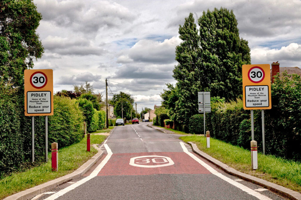
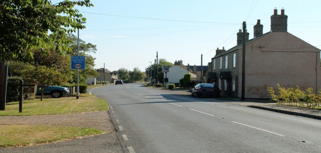
One of the four entrances into the village, this one showing the view from the Old Hurst direction with the 30 mph signs adorned with The Home of the Mountain Rescue Team thereon, truly a unique feature for such a small village
PREFACE
I would like to thank a number of people who have made the chronicles of Pidley Cum Fenton come to life after a promise I have held for many years, having lived in this lovely friendly village with my family. At the time of writing, some were at a grand old age, and it is this age that bears reliable confirmation and their accurate recollections and testimonies to much that is written and shown here in pictorial form. I hope it stands to remind us all of a close community spirit that endures today, and will be the benchmark for others in the future to continue with a chronicle of events and characters and features that occur in Pidley Cum Fenton.
Edna Wootten 98 years
Ailwyn Stephens 93 years
Alf Wootten 101 years (who sadly died in 2016)
Evelyn Wootten 93 years
Robert & Jo Birch
Kevin & Nicola Doyle
Keith & Gwen Garner
Bob Johnson & Sandra Johnson
Robert and Eleanor Lamb
INTRODUCTION
The villages of Pidley and Fenton lie in the dead centre of the new County boundaries of Cambridgeshire, approximately 7 miles (11km) north east of Huntingdon. The main village rises from the fen floor at 3 feet to 88 feet above sea level with even greater heights found through farming and irrigation to a maximum of 100 feet in places if Global Positioning Systems (GPS) are to be relied upon. This fact of being one of the highest points in Cambridgeshire is often relayed, when people talk about The Pidley Mountain Rescue Team which was started in the village, which goes from strength to strength helping those in the boundaries of Huntingdonshire with special needs.
The village name of Pidley originally meant “Woodland Clearing of a man called Pyda”.
In the 13th Century the combined villages were known on maps and documents as Pidele et Fenton with some showing listed as Pydele, Puddele or Pidel, in documents held at Ely Abbey. During this period the Manor House came under the direct control of the Bishop of Ely with much land in and around the two villages owned by the diocese even to this day, which includes the immediate field next to the village hall in Warboys Road.
POPULATION & DEMOGRAPHY
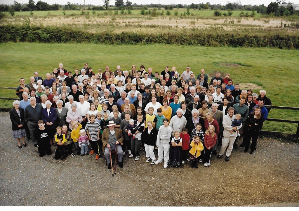
I have kept an eye on the population growth of our villages over the years, and the following figures show an interesting rise and fall from 1801 to 2011. From 1801 the first national census was recorded with 262 people as living in our two communities. Thereafter the National Census was recorded every 10 years. The photo below was taken in Sep 1999 as a Millenium photo of the villagers.
For unknown reasons the highest number recorded in the villages was in 1871, when 587 people were officially recorded, with only 1931 coming close at 555. This could be natural resettlement between World Wars where farming and physical labour became a main ingredient of employment. You will notice that the Census of 1941 is missing from my table below. This omission was caused by the Second World War and the calling up of individuals of the correct ages, and the migration of many skills to work on the land from other Counties as food provision became essential as the country stood alone in those dark early years.
| Year of Census | 1911 | 1921 | 1931 | 1951 | 1961 | 1971 | 1981 | 1991 | 2001 | 2011 |
| Pidley-cum-Fenton | 366 | 426 | 555 | 399 | 376 | 317 | 321 | 337 | 367 | 388 |
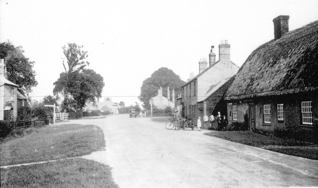
The above image was taken from the Oldhurst direction facing the junction to Warboys on the left indicated by the finger board, and the Mad Cat pub on the right. The date of the photograph is believed to have been taken at around 1930 as the motor vehicle outside the pub has the correct proportions for an Austin 7 Chummy, using the two ladies as a height comparison and the configuration of the headlights, cockpit and mudguards as a guide. This however, cannot be confirmed, but the dress of the family on the right bears some accuracy on the rough date.
One has to look closely at photographs of this quality, at features that are still with us today in 2016. The oak trees and buildings on the right and left of Oldhurst Road with chimney stacks featuring as continuity even today, and also the bake house on the left in the distance now called The Old Bake house. This being the home to Edna Wootten aged 98 years who was once the landlady of the Mad Cat Inn with her husband Doug.
Just a short walk up the High Street and past the Mad Cat Inn towards Somersham, lies the village water pump between the new bus shelter and the newly constructed Eden House. Many will not have known of its existence, in a shady part of the High Street, carefully restored annually as part of our village history. This was used heavily right up until 1949. One must not forget of course, Pidley struggled to become part of a mains sewage system, and it was as recently as 1996 when those that wanted to be connected did so, and even now many houses still operate their own sewage plant or klargesters.

Set back on the High Street, are two of the oldest houses in the village. The cottage along The Drive is alleged to be the oldest character cottage in the village dated before 1650. Also one of the other oldest homes in the village is Stanley House in Oldhurst Road, dated at approximately as 1710.
Homeleigh Farm is next door to The Drive and opposite the Mad Cat Pub, set back off the High Street. This has been the Johnson home from before 1900 starting its life as a red brick dwelling.
As you travel down Warboys road from the Mad Cat junction a house on the left, on the corner, formerly the home of Peter & Beryl Wilderspin, hides a war time secret. Many will not have noticed the bricked in doorway at the front of the property, but this was the room allocated as the village morgue in WW2. Only one person was ever held in this facility, a feature seen in many English villages. His name was Billy Bucket, a 5 year old evacuee from London who drowned in the Moat Pond. This has long been filled in and was situated between Strawberry End and Moat House.
Opposite the Wilderspin’s former home is the site of the Blacksmiths Shop in Drag Lane named Anvil Cottage. The field on the left as you stroll down the lane is known on Pidley maps as Blacksmiths Close, although no houses have been built on it.
Along Warboys Road, on the right is a field which appears to be the remains of a Ridge and Furrow system which, in Middle Ages was apportioned to villagers by a land owner in individual strips or small holdings to grow crops and vegetables. This is a rare sight nowadays. This is also evident in the Church Commissioners owned field next to the village hall, a small plot next to the church and Hayden Hall Farm.
Further down Warboys road, the village hall and social club are on our right. The facilities there have always been run by volunteers from within the community. They are currently run by Anthony Wootten as Chairman of the Social Club, and Sandra Johnson, Chairperson for the village hall, which provide full facilities for those wanting to hire out the venue, and has held many memorable events over the years for the benefit of the villagers.
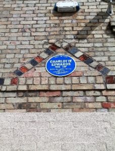
The kitchen was updated a number of years ago by The Pidley Mountain Rescue Team, who also use the hall as their base. A blue plaque can be seen above the village hall fire door, which signifies ten years as the England Women’s Cricket Team Captaincy of Pidley’s own Charlotte Edwards MBE CBE 2006- 2016, and placed there in gratitude of her service by the people of Pidley Cum Fenton.
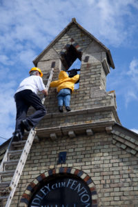
The small child on the bell tower signifies the original logo of the Pidley Mountain Rescue Team of an abseiling child.
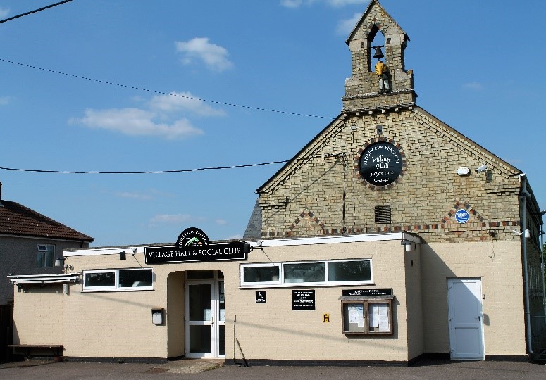
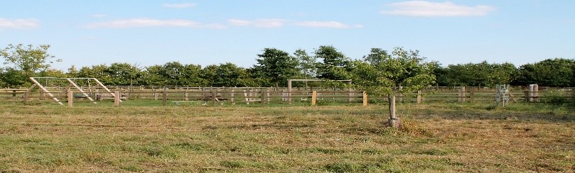
Located next to the Village Hall is the newly appointed children’s play area, built on land donated by local David Hopkins of Lakeside Lodge Golf Centre in 2014. The play facilities within it, the initial idea coming from Lily Steward, and Joy Ayres, were funded by local charitable organisations with a strong committee of volunteers making it happen, headed by Dave Bird, Parish Councillor, his wife Lucy, Martin Steward, Jackie Ayres, Angela Parker, Sam Smith and many more all giving of their time to make this all happen on behalf of the communities’ children. In the foreground to the right planted in the village field, is the tree commemorating 50 years’ service by Michael Newman to the Parish Council as its Chairman, and protected by an ornate galvanised frame for the future.
As we move down Warboys Road, we come to Pidley “Hoss Pond” as it is affectionately known throughout the Fens, at the junction with Fen Road.
The pond has changed very little over the years if you use the two photos below as comparisons. The first was taken in 1923, and this is confirmed by Ailwyn Stephens, then aged 2 months, who is held in his mother Martha’s arms at the door of their council house, along with his two young brothers, William Roy aged 2 years, and Kenneth Herbert Stephens aged 1 seated on the doorstep.
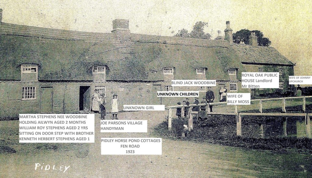
Immediately in front of Martha Stephens is Joe Parsons the village handyman and an unknown village girl.
The tall darkly dressed male on the pond railings is Jack Woodbine who was blind. The children there are all unknown. If one looks to the immediate right on this photograph, you can see the brick built cottages. The left hand one was the Royal Oak Public House and the landlord at the time was a Mr Bitten who brewed his own beer, which many small village pubs did in those days of non-regulation on breweries producing alcohol.
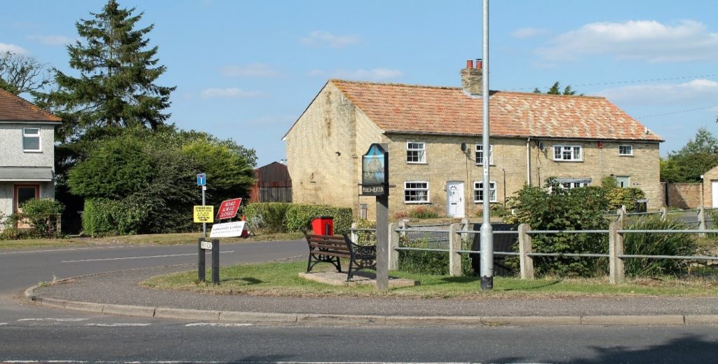
The above image shows the home of the late Alf Wootten, The Cottage which was formerly “The Royal Oak” pub and next door to “Albion Rose” cottage on the far right, the only two remaining dwellings from that 1923 photograph.
Due primarily to the location of the village right in the middle of the Fens and the agricultural workers who availed themselves of a pint on many occasions, the village and Fenton had five pubs as listed in the 1880 Census, they were:
The Royal Oak located at the village pond and Fen Road latterly the home of Alf Wootten, who died in 2016, aged 101 years of age.
The Mad Cat Inn, High Street.
The Butchers Arms which is the house immediately next to the Mad Cat Inn called Wayside today in the High Street.
The Three Horseshoes which was located at Hayden House in the High Street near the junction with Sheep Lane.
The Red Lion which was located at the house on the hill as you enter Fenton.
So one can see there were a few drinking houses for the amount of people that lived in the villages of drinking age shown in the Census.
The village has always had a Post Office, up until, when the last one closed at the old garage site in the High Street in 1990, which now accommodates two homes namely “Withycroft” and “The Warren”
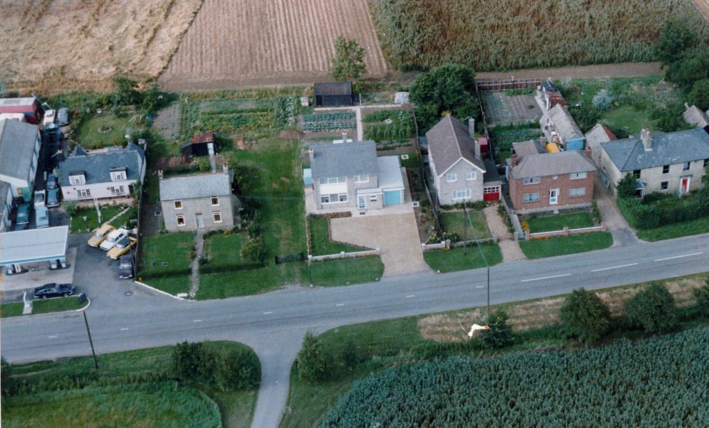
Aerial photo showing the Pidley garage and Post Office to the left of The Haven in the High Street opposite Hayden Hall Farm in 1980
Note the Aston Martin DB5 on the forecourt
The former locations of the Post Office in the village were Oldhurst Road, Warboys Road and the High Street as mentioned above. Once during the Second World War, an Australian crew, who had bailed out of their Wellington Bomber in Fen Road and landed in pits there, made their way to the Post Office, which used to be located in the row of cottages where Paddy Buddle now lives in Oldhurst Road. The Post Mistress at the time provided them all with tea and cakes until their recovery later that day.
A German bomber, having dropped most of his bombs on RAF Wyton during 1942, decided to drop what he had left on Pidley. A stick of bombs landed on the slope and flat part of the roadway as you enter Pidley from Oldhurst and the indentations can still be seen today where many years of tarmac and surface dressings have failed to hide the scars.
Pidley was surrounded by airfields during the war years, with the majority forming part of the “Pathfinder” Squadrons whose task it was to precede all bomber attacks and illuminate the intended targets for those who were to follow. In fact number 46 Squadron Royal Flying Corps was formed at RAF Wyton in 1916 and on the 1st of April 1918, the Royal Air Force was formed at the camp.
Flying training ceased there on the 25th March 2013 whereupon the Cambridge University Air Squadron was relocated to RAF Cranwell in Lincolnshire and RAF Wittering near Peterborough.
The pilots during World War Two war were brave men, and as part of their duties, were also called upon to evaluate and trial new equipment, which led to many tragedies for air crew and local people alike. One such tragedy was in on 5th October 1942 when a Wellington bomber crashed on houses as you enter Somersham, killing 10 local people in their homes.
A lone plaque sits on the wall of the newly constructed homes at Carpenters Court on the corner as you enter Somersham shown below, sadly many people pass it daily without knowing of its existence and the sacrifice made by villagers.
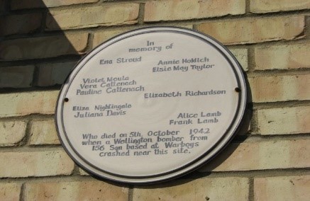
It was the 5th of October 1942, the target was Aachen in Germany. 257 aircraft made up of – 101 x Wellingtons, 74 x Lancasters, 59 x Halifaxes, 23 x Stirlings were involved.
10 x aircraft – namely 5 x Halifaxes, 2 x Stirlings, 2 x Wellingtons, 1 x Lancaster were lost. Six aircraft from 156 Squadron took off from RAF Warboys and others from RAF Upwood and beyond.
CLOSER TO HOME
Many tales surround these wartime squadrons and their losses, and sadly Hayden Hall Farm in Pidley became a tragic crash site for one such Mosquito aircrew from RAF Warboys on the 22nd July 1944.
Only in the last 15 years, when we had a knock on our door, did we realise the connection between the Pilot, Flight Lieutenant John Wilmer of that plane, and the frail lady who stood on our doorstep, and the co-pilot/navigator Flying Officer Adam McConnel-Jones.
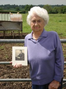
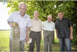
I took this photo of Mrs Myrtle Benbow on the 13th April 2007, who was the fiancée, of Adam McConnell-Jones who wanted to visit the crash site, holding a picture of him. Photo showing her in Hayden Hall Farm. The second photo shows from left to right, Stanton Wilmer a relative of the pilot, Keith Garner, High Street, who was a small boy at the time of the crash and saw the aircraft burning on the ground in the field at the rear of the farm house, Robert Birch the current owner of Hayden Hall Farm and Bill Johnstone a metal detectorist unveiling the plaque at the crash site. If you want to visit the memorial post, please contact Robert or Jo Birch beforehand as it is on their private land.
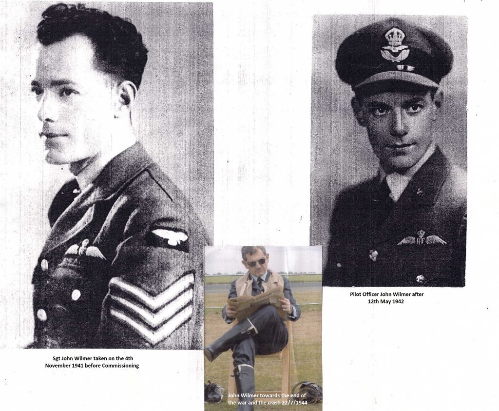
One can perhaps make a direct comparison on the looks of Flight Lieutenant John Wilmer in 1941 and later in the war after many exhaustive sorties and attrition rates from the colour photo taken in 1944 in the centre
I am sure many residents hold stories of those people and events that occurred in and around our village over the years, and this picture taken in 1948 shows some of the characters who lived here then, taken outside the Mad Cat Inn where after many years, I have endeavoured to get the names of all those pictured. If you know the name of the missing man please let me know. Alf Wootten shown at the bottom right of the photo helped me name these characters, but died in 2016. One amendment on the below image should read Joe Behagg not Vehag.
Here are two images of the Mad Cat back in those heady days showing the brewery as Huntingdon Ales which has long since disappeared.
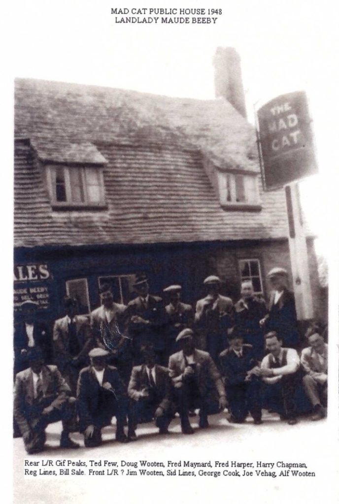
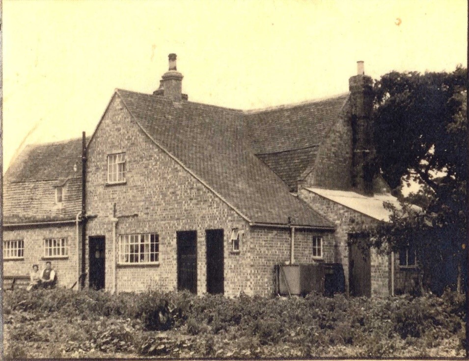
The below image is that of the rear of the Mad Cat with the landlord Mr and Mrs Maude Beeby shown. I am reliably informed the two black doors on the right were the men’s and ladies toilets then. The other door is the existing rear entrance to the pub.
As we move down Warboys Road passed the Baptist Chapel, the Village church stands in its solitary position as it has done for hundreds of years. As you enter the gates, immediately on the left lies the 13th Century grave of an unknown person. The ornate engravings show the person must have been someone of some standing.
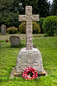
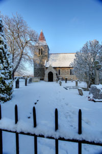
The granite village war memorial is positioned on the right hand side as you follow the footpath. The village sacrificed seven men during the First World War and one during WW2. Sadly Bert Parsons a villager who was serving in the Army during WW2 drowned at the pumping station in Fen Road whilst home on leave his name appears on the memorial. The church photo taken in December 1991.
At the time of writing, I would like to mention the imminent award of the Legion d’ Honeur which will be awarded to Ailwyn Stephens aged 93 by the French Government, for his brave service as a Royal Marine, who was one of the first to hit the beaches of Normandy in the early hours of 6th of June 1944. I was privileged as an ex member of The Parachute Regiment to obtain for those ex veterans in the village who had not received their wartime medals, their actual allocation of medals from the Ministry of Defence, which included Geoff Beeby RIP, Arnie Beeby RIP, Don Johnson and Ailwyn Stephens.
I have been meaning to do these Chronicles for a number of years, and would like to think it can form part of the village website, and added to by anybody at any time, who has photos or more information on the village history to ensure it is accurately recorded for future generations.
Gil Boyd
September 2016